SlideShare uma empresa Scribd logo
1 de 1
Baixar para ler offline
What is
Photogrammetry?
http://www.merriam-webster.com/dictionary/photogrammetry
From the good folks at Merriam-Webster:
pho·to·gram·me·try
DEFINITION:
the science of making reliable measure-
ments by the use of photographs and
especially aerial photographs
(as in surveying)
ORIGINS:
International Scientific Vocabulary
“photogram” photograph
(from phot- + -gram) + -metry
DATES BACK TO: 1875
There’s a lot more to
the story...
Since the day Wilbur
and Orville Wright
turned a bicycle into
a flying machine, pho-
togrammetry and
the airplane were
destined for one
another.
An industry is born:
AERIAL PHOTOGRAMMETRY
As it turns out, the world was never flat. However, an easy way to get up in
the air to cover the earth with an accurate map was almost non-existent. Sure,
there were hot air-balloons and kites, but that was hardly a recipe for a
controlled environment. Other mapping means were not functional as the second
industrial revolution spurned
skylines that made perspec-
tive mapping accuracy a near
impossibility.
It only took five years after
the Wright Brothers’ first
flight for Italian Captain
Cesare Tardivo to use the
airplane to take the first
aerial photos for mapping
purposes. By 1914 the first
mounted camera made its way
onto an airplane. In short,
it took less than fifteen
years for an industry to get
off the ground (literally).
The technology went from
earth to sky, but didn’t stop
there...
In 1924 Fairchild created the first aerial mosaic of Manhattan
Island. Fairchild used over 100 aerial photos to stitch together
the most detailed map the world had seen to that point.
Source: NYC.gov
October 4, 1957, 7:28 PM is a day that stuck like glue
for those who were old enough at the time to remember it.
The world changed forever when the USSR launched Sputnik,
the world’s first satellite, into orbit. It was just 2
years later in 1959 when Explorer VI, an American satel-
lite, took the first picture of the earth. Like many ad-
vancements in technology from that era, the meteoric rise
of satellite technology during the cold war was a byprod-
uct of the struggle for supremacy between the USSR and
the USA. In fact there are currently (2014) 2,271 satellites in orbit around the
Earth.
In April of 2005 Google added satellite imagery to its broadening map viewing
platform, signifying a shift in accessibility of satellite mapping. To date over
1 billion people around the world have downloaded Google Earth. Commercially,
stereo satellite imagery provides a great resource for orthoimagery creation on
a global scale.
...and how has it evolved?
Sputnik
(Image source: NASA)
From sky to space:
SATELLITE IMAGERY
UAS, or drones, as they are commonly known, are the latest advancement in
the photogrammetric process. As alluded to above, balloons and kites
were sometimes used for aerial imagery, but they had some obvious
shortcomings. In 1937 the first competition was held for
a new kind of hobby: remote control aircraft. These remote
control aircraft were merely toys at their outset, but
they’re actually the predecessor to today’s drones. Although the term “drone”
can attract negative attention as a tool of espionage and war, they are also
broadening the possibilities of mapping firms around
the world. Today drone capabilities are being inte-
grated to increase the speed, efficiency and cost ef-
fectiveness of data collection and mapping.
For a deeper look at drones, and their integration
into society, please check out our other infographics
across multiple social media platforms.
Massive Expansion in Image Acquisition:
UNMANNED AERIAL SYSTEMS(UAS)
Drone derived imagery
The orthorectification process removes
all distortion from the earth, as well
as those due to forces of motion from
the aircraft. These “orthos,” as they
are often referenced as, feature the
same scale across the image, which makes
them ideal for high-accuracy mapping.
NOTE: This is a brief overview, and a far cry from what’s
involved in the photogrammetric process. For more
information please visit: www.continentalmapping.com
BEFORE AFTER

Mais conteúdo relacionado

Mais procurados

Photogrammetry for Architecture and Construction
Photogrammetry for Architecture and ConstructionPhotogrammetry for Architecture and Construction
Photogrammetry for Architecture and ConstructionDat Lien
 
Height measurement of aerial photograph
Height measurement of aerial photographHeight measurement of aerial photograph
Height measurement of aerial photographvidyasagar university
 
Photogrammetry Surveying, its Benefits & Drawbacks
Photogrammetry Surveying, its Benefits & DrawbacksPhotogrammetry Surveying, its Benefits & Drawbacks
Photogrammetry Surveying, its Benefits & DrawbacksNI BT
 
Aerial photographs and their interpretation
Aerial photographs and their interpretationAerial photographs and their interpretation
Aerial photographs and their interpretationSumant Diwakar
 
Lecture 08 tilted photograph
Lecture 08  tilted photographLecture 08  tilted photograph
Lecture 08 tilted photographSarhat Adam
 
Close range Photogrammeetry
Close range PhotogrammeetryClose range Photogrammeetry
Close range Photogrammeetrychinmay khadke
 
01 introdcution to photogrammetry
01 introdcution to photogrammetry01 introdcution to photogrammetry
01 introdcution to photogrammetrySarhat Adam
 
Lecture 6 vertical photographs
Lecture 6  vertical photographsLecture 6  vertical photographs
Lecture 6 vertical photographsSarhat Adam
 
TerraSAR-X and TanDEM-X
TerraSAR-X and TanDEM-XTerraSAR-X and TanDEM-X
TerraSAR-X and TanDEM-XAbran Idrees
 
Height measurement of aerial photography
Height measurement of aerial photographyHeight measurement of aerial photography
Height measurement of aerial photographyvidyasagar university
 
Lecture01: Introduction to Photogrammetry
Lecture01: Introduction to PhotogrammetryLecture01: Introduction to Photogrammetry
Lecture01: Introduction to PhotogrammetrySarhat Adam
 

Mais procurados (20)

Presentation
PresentationPresentation
Presentation
 
Photogrammetry for Architecture and Construction
Photogrammetry for Architecture and ConstructionPhotogrammetry for Architecture and Construction
Photogrammetry for Architecture and Construction
 
Height measurement of aerial photograph
Height measurement of aerial photographHeight measurement of aerial photograph
Height measurement of aerial photograph
 
Introduction of photogrammetry
Introduction of photogrammetryIntroduction of photogrammetry
Introduction of photogrammetry
 
Photogrammetry Surveying, its Benefits & Drawbacks
Photogrammetry Surveying, its Benefits & DrawbacksPhotogrammetry Surveying, its Benefits & Drawbacks
Photogrammetry Surveying, its Benefits & Drawbacks
 
Aerial photographs and their interpretation
Aerial photographs and their interpretationAerial photographs and their interpretation
Aerial photographs and their interpretation
 
Remote sensing
Remote sensingRemote sensing
Remote sensing
 
Photogrammetry chandu
Photogrammetry chanduPhotogrammetry chandu
Photogrammetry chandu
 
Photogrammetry chandu
Photogrammetry chanduPhotogrammetry chandu
Photogrammetry chandu
 
Lecture 08 tilted photograph
Lecture 08  tilted photographLecture 08  tilted photograph
Lecture 08 tilted photograph
 
Close range Photogrammeetry
Close range PhotogrammeetryClose range Photogrammeetry
Close range Photogrammeetry
 
01 introdcution to photogrammetry
01 introdcution to photogrammetry01 introdcution to photogrammetry
01 introdcution to photogrammetry
 
Stereoscopic vision
Stereoscopic visionStereoscopic vision
Stereoscopic vision
 
Lecture 6 vertical photographs
Lecture 6  vertical photographsLecture 6  vertical photographs
Lecture 6 vertical photographs
 
TerraSAR-X and TanDEM-X
TerraSAR-X and TanDEM-XTerraSAR-X and TanDEM-X
TerraSAR-X and TanDEM-X
 
Photogrammetry
PhotogrammetryPhotogrammetry
Photogrammetry
 
Height measurement of aerial photography
Height measurement of aerial photographyHeight measurement of aerial photography
Height measurement of aerial photography
 
Lecture01: Introduction to Photogrammetry
Lecture01: Introduction to PhotogrammetryLecture01: Introduction to Photogrammetry
Lecture01: Introduction to Photogrammetry
 
Photogrammetry
PhotogrammetryPhotogrammetry
Photogrammetry
 
Principles of photogrammetry
Principles of photogrammetryPrinciples of photogrammetry
Principles of photogrammetry
 

Destaque

Photogrammetry- Surveying
Photogrammetry- SurveyingPhotogrammetry- Surveying
Photogrammetry- SurveyingGokul Saud
 
Aerial mapping services
Aerial mapping servicesAerial mapping services
Aerial mapping servicesEaglelens
 
(2015/09) Drone Imagery Economics
(2015/09) Drone Imagery Economics(2015/09) Drone Imagery Economics
(2015/09) Drone Imagery EconomicsMartin Scholl
 
Mapping with Unmanned Airborne Systems (UAS)
Mapping with Unmanned Airborne Systems (UAS)Mapping with Unmanned Airborne Systems (UAS)
Mapping with Unmanned Airborne Systems (UAS)Merrick & Company
 
GeoMonday 2015.3 – A practical guide to use drones
GeoMonday 2015.3 – A practical guide to use dronesGeoMonday 2015.3 – A practical guide to use drones
GeoMonday 2015.3 – A practical guide to use dronesGeo Monday
 
Using Drones For Aerial Imagery
Using Drones For Aerial ImageryUsing Drones For Aerial Imagery
Using Drones For Aerial ImagerySimon Handley
 
Remote Sensing with a Drone
Remote Sensing with a DroneRemote Sensing with a Drone
Remote Sensing with a DroneTravis Peterson
 
Aerial photography and remote sensing
Aerial photography and remote sensingAerial photography and remote sensing
Aerial photography and remote sensingakshitakohli
 
Digital image classification
Digital image classificationDigital image classification
Digital image classificationAleemuddin Abbasi
 
Aerial photography abraham thomas
Aerial photography abraham thomasAerial photography abraham thomas
Aerial photography abraham thomasSumant Diwakar
 
Principle of aerial photography and types.ppt
Principle of aerial photography and types.pptPrinciple of aerial photography and types.ppt
Principle of aerial photography and types.pptsrinivas2036
 
Introduction to aerial photography and photogrammetry.ppt
Introduction to aerial photography and photogrammetry.pptIntroduction to aerial photography and photogrammetry.ppt
Introduction to aerial photography and photogrammetry.pptsrinivas2036
 
Lecture on photogrammetry
Lecture on photogrammetryLecture on photogrammetry
Lecture on photogrammetryWaleed Liaqat
 

Destaque (15)

Photogrammetry- Surveying
Photogrammetry- SurveyingPhotogrammetry- Surveying
Photogrammetry- Surveying
 
Aerial mapping services
Aerial mapping servicesAerial mapping services
Aerial mapping services
 
(2015/09) Drone Imagery Economics
(2015/09) Drone Imagery Economics(2015/09) Drone Imagery Economics
(2015/09) Drone Imagery Economics
 
Mapping with Unmanned Airborne Systems (UAS)
Mapping with Unmanned Airborne Systems (UAS)Mapping with Unmanned Airborne Systems (UAS)
Mapping with Unmanned Airborne Systems (UAS)
 
Presentazione drone
Presentazione dronePresentazione drone
Presentazione drone
 
GeoMonday 2015.3 – A practical guide to use drones
GeoMonday 2015.3 – A practical guide to use dronesGeoMonday 2015.3 – A practical guide to use drones
GeoMonday 2015.3 – A practical guide to use drones
 
Using Drones For Aerial Imagery
Using Drones For Aerial ImageryUsing Drones For Aerial Imagery
Using Drones For Aerial Imagery
 
Remote Sensing with a Drone
Remote Sensing with a DroneRemote Sensing with a Drone
Remote Sensing with a Drone
 
Photogrammetry1
Photogrammetry1Photogrammetry1
Photogrammetry1
 
Aerial photography and remote sensing
Aerial photography and remote sensingAerial photography and remote sensing
Aerial photography and remote sensing
 
Digital image classification
Digital image classificationDigital image classification
Digital image classification
 
Aerial photography abraham thomas
Aerial photography abraham thomasAerial photography abraham thomas
Aerial photography abraham thomas
 
Principle of aerial photography and types.ppt
Principle of aerial photography and types.pptPrinciple of aerial photography and types.ppt
Principle of aerial photography and types.ppt
 
Introduction to aerial photography and photogrammetry.ppt
Introduction to aerial photography and photogrammetry.pptIntroduction to aerial photography and photogrammetry.ppt
Introduction to aerial photography and photogrammetry.ppt
 
Lecture on photogrammetry
Lecture on photogrammetryLecture on photogrammetry
Lecture on photogrammetry
 

Semelhante a Photogrammetry

HISTORY AND DEVELOPMENT OF REMOTE SENSING (FRM 180).pptx
HISTORY AND DEVELOPMENT OF REMOTE SENSING (FRM 180).pptxHISTORY AND DEVELOPMENT OF REMOTE SENSING (FRM 180).pptx
HISTORY AND DEVELOPMENT OF REMOTE SENSING (FRM 180).pptxChrissyMee
 
Building%20Blocks%20To%20Space
Building%20Blocks%20To%20SpaceBuilding%20Blocks%20To%20Space
Building%20Blocks%20To%20SpaceDavidSP1996
 
Louis: TIROS-1
Louis: TIROS-1Louis: TIROS-1
Louis: TIROS-1jtrip
 
Imagination innovation space exploration
Imagination innovation space explorationImagination innovation space exploration
Imagination innovation space explorationPeter Pappas
 
A Review- Remote Sensing
A Review- Remote Sensing A Review- Remote Sensing
A Review- Remote Sensing IJERA Editor
 
IMGIS - Brief History of Mapping
IMGIS - Brief History of MappingIMGIS - Brief History of Mapping
IMGIS - Brief History of MappingJohn Reiser
 
The Solar System
The Solar SystemThe Solar System
The Solar Systemauntlaurao
 
Satellite Lec 1.pptx
Satellite Lec 1.pptxSatellite Lec 1.pptx
Satellite Lec 1.pptxYonaCastro1
 
Visualizations and Mashups in Online News Production
Visualizations and Mashups in Online News ProductionVisualizations and Mashups in Online News Production
Visualizations and Mashups in Online News ProductionAndy Sternberg
 
SEMINAR REPORT ON SPACE EXPLORATION.
SEMINAR REPORT ON SPACE EXPLORATION.SEMINAR REPORT ON SPACE EXPLORATION.
SEMINAR REPORT ON SPACE EXPLORATION.Mohammad Athik
 
Satellite Communication Notes Unit (1 to 3).pdf
Satellite Communication Notes Unit (1 to 3).pdfSatellite Communication Notes Unit (1 to 3).pdf
Satellite Communication Notes Unit (1 to 3).pdfGopalakrishnaU
 
ba-in-history-major-contemporary-events.pptx
ba-in-history-major-contemporary-events.pptxba-in-history-major-contemporary-events.pptx
ba-in-history-major-contemporary-events.pptxArjayDadivas
 
SATELLITE COMMUNICATION OVERVIEW
SATELLITE COMMUNICATION OVERVIEWSATELLITE COMMUNICATION OVERVIEW
SATELLITE COMMUNICATION OVERVIEWAshwin Shroff
 
SPACE SCIENCE AND TECHNOLOGY FOR MANKIND
SPACE SCIENCE AND TECHNOLOGY FOR MANKINDSPACE SCIENCE AND TECHNOLOGY FOR MANKIND
SPACE SCIENCE AND TECHNOLOGY FOR MANKINDVishal Pandey
 

Semelhante a Photogrammetry (20)

RJW Back to the Future
RJW Back to the FutureRJW Back to the Future
RJW Back to the Future
 
Back to the Future: Rosetta
Back to the Future: RosettaBack to the Future: Rosetta
Back to the Future: Rosetta
 
HISTORY AND DEVELOPMENT OF REMOTE SENSING (FRM 180).pptx
HISTORY AND DEVELOPMENT OF REMOTE SENSING (FRM 180).pptxHISTORY AND DEVELOPMENT OF REMOTE SENSING (FRM 180).pptx
HISTORY AND DEVELOPMENT OF REMOTE SENSING (FRM 180).pptx
 
Building%20Blocks%20To%20Space
Building%20Blocks%20To%20SpaceBuilding%20Blocks%20To%20Space
Building%20Blocks%20To%20Space
 
Louis: TIROS-1
Louis: TIROS-1Louis: TIROS-1
Louis: TIROS-1
 
Imagination innovation space exploration
Imagination innovation space explorationImagination innovation space exploration
Imagination innovation space exploration
 
A Review- Remote Sensing
A Review- Remote Sensing A Review- Remote Sensing
A Review- Remote Sensing
 
IMGIS - Brief History of Mapping
IMGIS - Brief History of MappingIMGIS - Brief History of Mapping
IMGIS - Brief History of Mapping
 
The Solar System
The Solar SystemThe Solar System
The Solar System
 
Satellite Lec 1.pptx
Satellite Lec 1.pptxSatellite Lec 1.pptx
Satellite Lec 1.pptx
 
Satcom overview
Satcom overviewSatcom overview
Satcom overview
 
Space Essays
Space EssaysSpace Essays
Space Essays
 
Visualizations and Mashups in Online News Production
Visualizations and Mashups in Online News ProductionVisualizations and Mashups in Online News Production
Visualizations and Mashups in Online News Production
 
SEMINAR REPORT ON SPACE EXPLORATION.
SEMINAR REPORT ON SPACE EXPLORATION.SEMINAR REPORT ON SPACE EXPLORATION.
SEMINAR REPORT ON SPACE EXPLORATION.
 
Satellite Communication Notes Unit (1 to 3).pdf
Satellite Communication Notes Unit (1 to 3).pdfSatellite Communication Notes Unit (1 to 3).pdf
Satellite Communication Notes Unit (1 to 3).pdf
 
ba-in-history-major-contemporary-events.pptx
ba-in-history-major-contemporary-events.pptxba-in-history-major-contemporary-events.pptx
ba-in-history-major-contemporary-events.pptx
 
Digital Imaging in Space
Digital Imaging in SpaceDigital Imaging in Space
Digital Imaging in Space
 
Space Exploration
Space ExplorationSpace Exploration
Space Exploration
 
SATELLITE COMMUNICATION OVERVIEW
SATELLITE COMMUNICATION OVERVIEWSATELLITE COMMUNICATION OVERVIEW
SATELLITE COMMUNICATION OVERVIEW
 
SPACE SCIENCE AND TECHNOLOGY FOR MANKIND
SPACE SCIENCE AND TECHNOLOGY FOR MANKINDSPACE SCIENCE AND TECHNOLOGY FOR MANKIND
SPACE SCIENCE AND TECHNOLOGY FOR MANKIND
 

Mais de Continental Mapping Consultants

Continental Mapping Projects - Tualatin National Wildlife Refuge
Continental Mapping Projects - Tualatin National Wildlife RefugeContinental Mapping Projects - Tualatin National Wildlife Refuge
Continental Mapping Projects - Tualatin National Wildlife RefugeContinental Mapping Consultants
 
Continental mapping projects las vegas water treatment plant
Continental mapping projects   las vegas water treatment plantContinental mapping projects   las vegas water treatment plant
Continental mapping projects las vegas water treatment plantContinental Mapping Consultants
 

Mais de Continental Mapping Consultants (20)

Continental Mapping Introduces TheGeoFoundry.com
Continental Mapping Introduces TheGeoFoundry.comContinental Mapping Introduces TheGeoFoundry.com
Continental Mapping Introduces TheGeoFoundry.com
 
Continental Mapping Projects - Wood Road Re-alignment
Continental Mapping Projects - Wood Road Re-alignmentContinental Mapping Projects - Wood Road Re-alignment
Continental Mapping Projects - Wood Road Re-alignment
 
Transportation Mapping
Transportation MappingTransportation Mapping
Transportation Mapping
 
Storygraphic - The Continental Mapping Story
Storygraphic - The Continental Mapping StoryStorygraphic - The Continental Mapping Story
Storygraphic - The Continental Mapping Story
 
Continental Mapping Projects - ATC Dane County
Continental Mapping Projects - ATC Dane CountyContinental Mapping Projects - ATC Dane County
Continental Mapping Projects - ATC Dane County
 
Continental Mapping Projects - USACE Cleveland Levee
Continental Mapping Projects - USACE Cleveland LeveeContinental Mapping Projects - USACE Cleveland Levee
Continental Mapping Projects - USACE Cleveland Levee
 
Continental Mapping Projects - USACE Pine Creek
Continental Mapping Projects - USACE Pine CreekContinental Mapping Projects - USACE Pine Creek
Continental Mapping Projects - USACE Pine Creek
 
Map America - 10 Tallest Dams Infographic
Map America - 10 Tallest Dams InfographicMap America - 10 Tallest Dams Infographic
Map America - 10 Tallest Dams Infographic
 
Continental Mapping Projects - Chattanooga
Continental Mapping Projects - ChattanoogaContinental Mapping Projects - Chattanooga
Continental Mapping Projects - Chattanooga
 
Continental Mapping Projects - Tualatin National Wildlife Refuge
Continental Mapping Projects - Tualatin National Wildlife RefugeContinental Mapping Projects - Tualatin National Wildlife Refuge
Continental Mapping Projects - Tualatin National Wildlife Refuge
 
Continental Mapping - On All Continents
Continental Mapping - On All Continents Continental Mapping - On All Continents
Continental Mapping - On All Continents
 
FAA UAS Map
FAA UAS MapFAA UAS Map
FAA UAS Map
 
Red Wing Bridge Project
Red Wing Bridge ProjectRed Wing Bridge Project
Red Wing Bridge Project
 
Aztalan Project
Aztalan ProjectAztalan Project
Aztalan Project
 
Continental Mapping Projects - FEMA Butler Co. MO
Continental Mapping Projects - FEMA Butler Co. MOContinental Mapping Projects - FEMA Butler Co. MO
Continental Mapping Projects - FEMA Butler Co. MO
 
Continental Mapping Projects - TDOT Grainger Co.
Continental Mapping Projects - TDOT Grainger Co.Continental Mapping Projects - TDOT Grainger Co.
Continental Mapping Projects - TDOT Grainger Co.
 
Continental mapping projects las vegas water treatment plant
Continental mapping projects   las vegas water treatment plantContinental mapping projects   las vegas water treatment plant
Continental mapping projects las vegas water treatment plant
 
Continental mapping projects indot south split
Continental mapping projects   indot south splitContinental mapping projects   indot south split
Continental mapping projects indot south split
 
Continental Mapping Projects - HWY F
Continental Mapping Projects - HWY FContinental Mapping Projects - HWY F
Continental Mapping Projects - HWY F
 
Continental Mapping Projects - Dodger Stadium
Continental Mapping Projects - Dodger StadiumContinental Mapping Projects - Dodger Stadium
Continental Mapping Projects - Dodger Stadium
 

Último

Labelling Requirements and Label Claims for Dietary Supplements and Recommend...
Labelling Requirements and Label Claims for Dietary Supplements and Recommend...Labelling Requirements and Label Claims for Dietary Supplements and Recommend...
Labelling Requirements and Label Claims for Dietary Supplements and Recommend...Lokesh Kothari
 
CALL ON ➥8923113531 🔝Call Girls Kesar Bagh Lucknow best Night Fun service 🪡
CALL ON ➥8923113531 🔝Call Girls Kesar Bagh Lucknow best Night Fun service  🪡CALL ON ➥8923113531 🔝Call Girls Kesar Bagh Lucknow best Night Fun service  🪡
CALL ON ➥8923113531 🔝Call Girls Kesar Bagh Lucknow best Night Fun service 🪡anilsa9823
 
Nanoparticles synthesis and characterization​ ​
Nanoparticles synthesis and characterization​  ​Nanoparticles synthesis and characterization​  ​
Nanoparticles synthesis and characterization​ ​kaibalyasahoo82800
 
Pests of mustard_Identification_Management_Dr.UPR.pdf
Pests of mustard_Identification_Management_Dr.UPR.pdfPests of mustard_Identification_Management_Dr.UPR.pdf
Pests of mustard_Identification_Management_Dr.UPR.pdfPirithiRaju
 
Forensic Biology & Its biological significance.pdf
Forensic Biology & Its biological significance.pdfForensic Biology & Its biological significance.pdf
Forensic Biology & Its biological significance.pdfrohankumarsinghrore1
 
Pulmonary drug delivery system M.pharm -2nd sem P'ceutics
Pulmonary drug delivery system M.pharm -2nd sem P'ceuticsPulmonary drug delivery system M.pharm -2nd sem P'ceutics
Pulmonary drug delivery system M.pharm -2nd sem P'ceuticssakshisoni2385
 
Animal Communication- Auditory and Visual.pptx
Animal Communication- Auditory and Visual.pptxAnimal Communication- Auditory and Visual.pptx
Animal Communication- Auditory and Visual.pptxUmerFayaz5
 
Disentangling the origin of chemical differences using GHOST
Disentangling the origin of chemical differences using GHOSTDisentangling the origin of chemical differences using GHOST
Disentangling the origin of chemical differences using GHOSTSérgio Sacani
 
Botany 4th semester file By Sumit Kumar yadav.pdf
Botany 4th semester file By Sumit Kumar yadav.pdfBotany 4th semester file By Sumit Kumar yadav.pdf
Botany 4th semester file By Sumit Kumar yadav.pdfSumit Kumar yadav
 
Biopesticide (2).pptx .This slides helps to know the different types of biop...
Biopesticide (2).pptx  .This slides helps to know the different types of biop...Biopesticide (2).pptx  .This slides helps to know the different types of biop...
Biopesticide (2).pptx .This slides helps to know the different types of biop...RohitNehra6
 
Botany 4th semester series (krishna).pdf
Botany 4th semester series (krishna).pdfBotany 4th semester series (krishna).pdf
Botany 4th semester series (krishna).pdfSumit Kumar yadav
 
Presentation Vikram Lander by Vedansh Gupta.pptx
Presentation Vikram Lander by Vedansh Gupta.pptxPresentation Vikram Lander by Vedansh Gupta.pptx
Presentation Vikram Lander by Vedansh Gupta.pptxgindu3009
 
GBSN - Biochemistry (Unit 1)
GBSN - Biochemistry (Unit 1)GBSN - Biochemistry (Unit 1)
GBSN - Biochemistry (Unit 1)Areesha Ahmad
 
9654467111 Call Girls In Raj Nagar Delhi Short 1500 Night 6000
9654467111 Call Girls In Raj Nagar Delhi Short 1500 Night 60009654467111 Call Girls In Raj Nagar Delhi Short 1500 Night 6000
9654467111 Call Girls In Raj Nagar Delhi Short 1500 Night 6000Sapana Sha
 
Green chemistry and Sustainable development.pptx
Green chemistry  and Sustainable development.pptxGreen chemistry  and Sustainable development.pptx
Green chemistry and Sustainable development.pptxRajatChauhan518211
 
Lucknow 💋 Russian Call Girls Lucknow Finest Escorts Service 8923113531 Availa...
Lucknow 💋 Russian Call Girls Lucknow Finest Escorts Service 8923113531 Availa...Lucknow 💋 Russian Call Girls Lucknow Finest Escorts Service 8923113531 Availa...
Lucknow 💋 Russian Call Girls Lucknow Finest Escorts Service 8923113531 Availa...anilsa9823
 
TEST BANK For Radiologic Science for Technologists, 12th Edition by Stewart C...
TEST BANK For Radiologic Science for Technologists, 12th Edition by Stewart C...TEST BANK For Radiologic Science for Technologists, 12th Edition by Stewart C...
TEST BANK For Radiologic Science for Technologists, 12th Edition by Stewart C...ssifa0344
 
Discovery of an Accretion Streamer and a Slow Wide-angle Outflow around FUOri...
Discovery of an Accretion Streamer and a Slow Wide-angle Outflow around FUOri...Discovery of an Accretion Streamer and a Slow Wide-angle Outflow around FUOri...
Discovery of an Accretion Streamer and a Slow Wide-angle Outflow around FUOri...Sérgio Sacani
 
Biological Classification BioHack (3).pdf
Biological Classification BioHack (3).pdfBiological Classification BioHack (3).pdf
Biological Classification BioHack (3).pdfmuntazimhurra
 
Spermiogenesis or Spermateleosis or metamorphosis of spermatid
Spermiogenesis or Spermateleosis or metamorphosis of spermatidSpermiogenesis or Spermateleosis or metamorphosis of spermatid
Spermiogenesis or Spermateleosis or metamorphosis of spermatidSarthak Sekhar Mondal
 

Último (20)

Labelling Requirements and Label Claims for Dietary Supplements and Recommend...
Labelling Requirements and Label Claims for Dietary Supplements and Recommend...Labelling Requirements and Label Claims for Dietary Supplements and Recommend...
Labelling Requirements and Label Claims for Dietary Supplements and Recommend...
 
CALL ON ➥8923113531 🔝Call Girls Kesar Bagh Lucknow best Night Fun service 🪡
CALL ON ➥8923113531 🔝Call Girls Kesar Bagh Lucknow best Night Fun service  🪡CALL ON ➥8923113531 🔝Call Girls Kesar Bagh Lucknow best Night Fun service  🪡
CALL ON ➥8923113531 🔝Call Girls Kesar Bagh Lucknow best Night Fun service 🪡
 
Nanoparticles synthesis and characterization​ ​
Nanoparticles synthesis and characterization​  ​Nanoparticles synthesis and characterization​  ​
Nanoparticles synthesis and characterization​ ​
 
Pests of mustard_Identification_Management_Dr.UPR.pdf
Pests of mustard_Identification_Management_Dr.UPR.pdfPests of mustard_Identification_Management_Dr.UPR.pdf
Pests of mustard_Identification_Management_Dr.UPR.pdf
 
Forensic Biology & Its biological significance.pdf
Forensic Biology & Its biological significance.pdfForensic Biology & Its biological significance.pdf
Forensic Biology & Its biological significance.pdf
 
Pulmonary drug delivery system M.pharm -2nd sem P'ceutics
Pulmonary drug delivery system M.pharm -2nd sem P'ceuticsPulmonary drug delivery system M.pharm -2nd sem P'ceutics
Pulmonary drug delivery system M.pharm -2nd sem P'ceutics
 
Animal Communication- Auditory and Visual.pptx
Animal Communication- Auditory and Visual.pptxAnimal Communication- Auditory and Visual.pptx
Animal Communication- Auditory and Visual.pptx
 
Disentangling the origin of chemical differences using GHOST
Disentangling the origin of chemical differences using GHOSTDisentangling the origin of chemical differences using GHOST
Disentangling the origin of chemical differences using GHOST
 
Botany 4th semester file By Sumit Kumar yadav.pdf
Botany 4th semester file By Sumit Kumar yadav.pdfBotany 4th semester file By Sumit Kumar yadav.pdf
Botany 4th semester file By Sumit Kumar yadav.pdf
 
Biopesticide (2).pptx .This slides helps to know the different types of biop...
Biopesticide (2).pptx  .This slides helps to know the different types of biop...Biopesticide (2).pptx  .This slides helps to know the different types of biop...
Biopesticide (2).pptx .This slides helps to know the different types of biop...
 
Botany 4th semester series (krishna).pdf
Botany 4th semester series (krishna).pdfBotany 4th semester series (krishna).pdf
Botany 4th semester series (krishna).pdf
 
Presentation Vikram Lander by Vedansh Gupta.pptx
Presentation Vikram Lander by Vedansh Gupta.pptxPresentation Vikram Lander by Vedansh Gupta.pptx
Presentation Vikram Lander by Vedansh Gupta.pptx
 
GBSN - Biochemistry (Unit 1)
GBSN - Biochemistry (Unit 1)GBSN - Biochemistry (Unit 1)
GBSN - Biochemistry (Unit 1)
 
9654467111 Call Girls In Raj Nagar Delhi Short 1500 Night 6000
9654467111 Call Girls In Raj Nagar Delhi Short 1500 Night 60009654467111 Call Girls In Raj Nagar Delhi Short 1500 Night 6000
9654467111 Call Girls In Raj Nagar Delhi Short 1500 Night 6000
 
Green chemistry and Sustainable development.pptx
Green chemistry  and Sustainable development.pptxGreen chemistry  and Sustainable development.pptx
Green chemistry and Sustainable development.pptx
 
Lucknow 💋 Russian Call Girls Lucknow Finest Escorts Service 8923113531 Availa...
Lucknow 💋 Russian Call Girls Lucknow Finest Escorts Service 8923113531 Availa...Lucknow 💋 Russian Call Girls Lucknow Finest Escorts Service 8923113531 Availa...
Lucknow 💋 Russian Call Girls Lucknow Finest Escorts Service 8923113531 Availa...
 
TEST BANK For Radiologic Science for Technologists, 12th Edition by Stewart C...
TEST BANK For Radiologic Science for Technologists, 12th Edition by Stewart C...TEST BANK For Radiologic Science for Technologists, 12th Edition by Stewart C...
TEST BANK For Radiologic Science for Technologists, 12th Edition by Stewart C...
 
Discovery of an Accretion Streamer and a Slow Wide-angle Outflow around FUOri...
Discovery of an Accretion Streamer and a Slow Wide-angle Outflow around FUOri...Discovery of an Accretion Streamer and a Slow Wide-angle Outflow around FUOri...
Discovery of an Accretion Streamer and a Slow Wide-angle Outflow around FUOri...
 
Biological Classification BioHack (3).pdf
Biological Classification BioHack (3).pdfBiological Classification BioHack (3).pdf
Biological Classification BioHack (3).pdf
 
Spermiogenesis or Spermateleosis or metamorphosis of spermatid
Spermiogenesis or Spermateleosis or metamorphosis of spermatidSpermiogenesis or Spermateleosis or metamorphosis of spermatid
Spermiogenesis or Spermateleosis or metamorphosis of spermatid
 

Photogrammetry

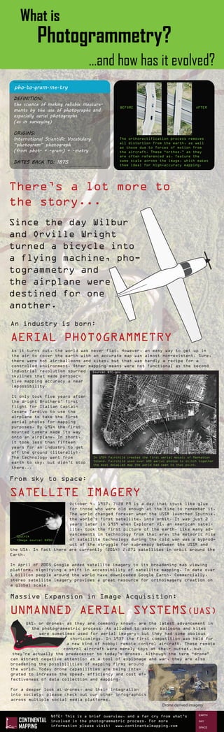
  • 1. What is Photogrammetry? http://www.merriam-webster.com/dictionary/photogrammetry From the good folks at Merriam-Webster: pho·to·gram·me·try DEFINITION: the science of making reliable measure- ments by the use of photographs and especially aerial photographs (as in surveying) ORIGINS: International Scientific Vocabulary “photogram” photograph (from phot- + -gram) + -metry DATES BACK TO: 1875 There’s a lot more to the story... Since the day Wilbur and Orville Wright turned a bicycle into a flying machine, pho- togrammetry and the airplane were destined for one another. An industry is born: AERIAL PHOTOGRAMMETRY As it turns out, the world was never flat. However, an easy way to get up in the air to cover the earth with an accurate map was almost non-existent. Sure, there were hot air-balloons and kites, but that was hardly a recipe for a controlled environment. Other mapping means were not functional as the second industrial revolution spurned skylines that made perspec- tive mapping accuracy a near impossibility. It only took five years after the Wright Brothers’ first flight for Italian Captain Cesare Tardivo to use the airplane to take the first aerial photos for mapping purposes. By 1914 the first mounted camera made its way onto an airplane. In short, it took less than fifteen years for an industry to get off the ground (literally). The technology went from earth to sky, but didn’t stop there... In 1924 Fairchild created the first aerial mosaic of Manhattan Island. Fairchild used over 100 aerial photos to stitch together the most detailed map the world had seen to that point. Source: NYC.gov October 4, 1957, 7:28 PM is a day that stuck like glue for those who were old enough at the time to remember it. The world changed forever when the USSR launched Sputnik, the world’s first satellite, into orbit. It was just 2 years later in 1959 when Explorer VI, an American satel- lite, took the first picture of the earth. Like many ad- vancements in technology from that era, the meteoric rise of satellite technology during the cold war was a byprod- uct of the struggle for supremacy between the USSR and the USA. In fact there are currently (2014) 2,271 satellites in orbit around the Earth. In April of 2005 Google added satellite imagery to its broadening map viewing platform, signifying a shift in accessibility of satellite mapping. To date over 1 billion people around the world have downloaded Google Earth. Commercially, stereo satellite imagery provides a great resource for orthoimagery creation on a global scale. ...and how has it evolved? Sputnik (Image source: NASA) From sky to space: SATELLITE IMAGERY UAS, or drones, as they are commonly known, are the latest advancement in the photogrammetric process. As alluded to above, balloons and kites were sometimes used for aerial imagery, but they had some obvious shortcomings. In 1937 the first competition was held for a new kind of hobby: remote control aircraft. These remote control aircraft were merely toys at their outset, but they’re actually the predecessor to today’s drones. Although the term “drone” can attract negative attention as a tool of espionage and war, they are also broadening the possibilities of mapping firms around the world. Today drone capabilities are being inte- grated to increase the speed, efficiency and cost ef- fectiveness of data collection and mapping. For a deeper look at drones, and their integration into society, please check out our other infographics across multiple social media platforms. Massive Expansion in Image Acquisition: UNMANNED AERIAL SYSTEMS(UAS) Drone derived imagery The orthorectification process removes all distortion from the earth, as well as those due to forces of motion from the aircraft. These “orthos,” as they are often referenced as, feature the same scale across the image, which makes them ideal for high-accuracy mapping. NOTE: This is a brief overview, and a far cry from what’s involved in the photogrammetric process. For more information please visit: www.continentalmapping.com BEFORE AFTER